|
As I often do when looking for a new idea for a project or proposal, I go "fishing" by performing a few web searches to see what surfaces. When I entered "Mapping Transitions" into a Google search, the very first link returned a website from the Advisory Group on Computer Graphics, a UK based educational think tank. "Mapping the Life Course: Visualising Migrations, Transitions & Trajectories" is a series of pages devoted to various graphic techniques for visualizing the lives of individuals, and groups of individuals. Many of the examples are based on a dataset from a rather unusual source -- an early British trade union, the Steam Engine Makers' Society, which listed in their Annual Reports both their membership records, including transfers between branches, and details of all benefit payments to members, including a "traveling benefit," which assisted members as they traveled around the country seeking work. From this dataset, it becomes possible to create a variety of graphics that map the life transitions of a great number of "common folk." Among the examples that instantly intrigued me was the graphic below, depicting a three-dimensional terrain and a time-based 3d line graph showing the movements of a single individual during the course of a day. 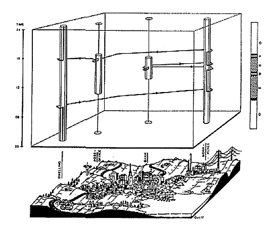 For a number of years now I have been using terrain, topography, and geographic information systems as source material for my artistic practice, so when I discovered this graphic in the first link from a general Google search on "Mapping Transitions," the serendipitous connection was too great to ignore, and I decided once again to utilize geography as the canvas for an exploration of the theme. Geography will literally function as the "Map." Another important source for my work has been the computer gaming industry. I've recently been interested in what is known as the "A*" algorithm (pronounced A-star) -- a methodology used by autonomous characters in a computer game to find an efficient path from one point to another across a terrain, avoiding obstacles, mountainous areas and the like. The A* algorithm would be the basis for the "Transition" being mapped. We often hear the terms "Political Landscape" and "Emotional Terrain." Frequently, we use the metaphor of a landscape to describe a seemingly unrelated human condition, be it political or personal. For the "Mapping Transitions" online exhibition, I decided to create a series of global terrains that relate to the aforementioned metaphors. The first terrain is simply a 3d relief map of the earth, created from my existing global dataset compiled for my previous project, "EARTH". The second terrain will be created from a World Health Organization online database of global health statistics. Taking statistics relating specifically to mental health, I translate the incidents of mental illness into an elevation, replacing the existing topography of the earth with a landscape created from the mental condition of its inhabitants. The third topography is similarly generated, but using statistics relating to human rights abuses around the world. Additional topographies will be generated based on datasets I subsequently discover during the development of the project. Once the terrains are generated, they then become the surface for the A* methodology. Though typically used in computer games, I realized that the A* algorithm could be highly successful as an unconventional graphing technique. Any dataset can be graphed as a terrain, and the A* algorithm can be applied to that terrain to produce a visual analysis of that dataset. In my project, I will place a "character" at every ten degrees of latitude, and tell them to find the path of least resistance across the surface of the earth, be it the real terrain, the political terrain, or the emotional terrain. The result I feel, will be a compelling visual comparison and representation of a particularly intriguing source dataset. John Klima
|